Sunday 31 July 2016

Day 7 (23 July 2016 ) - Yosemite Trees and trails

Introduction

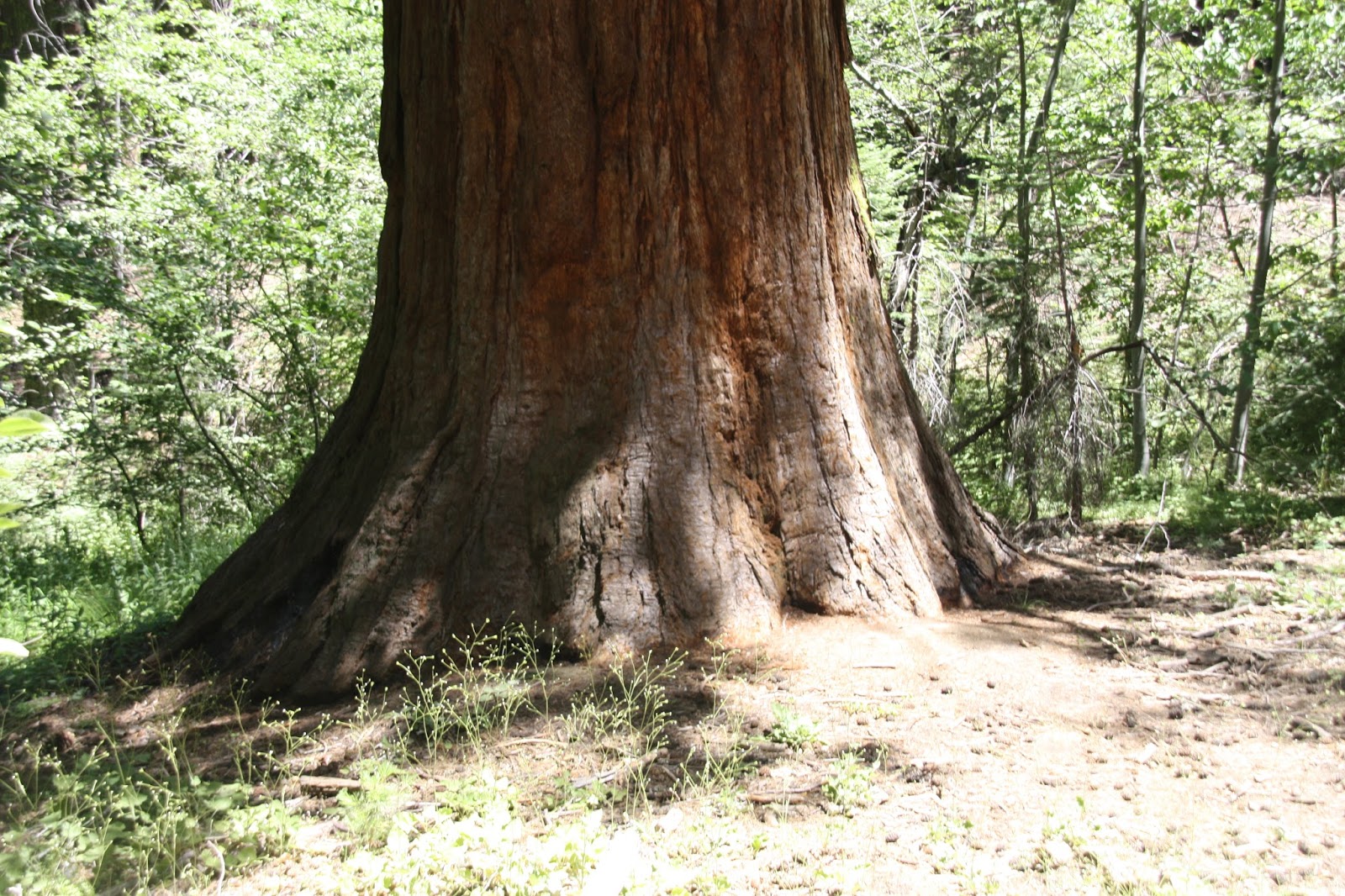
You have to remember only a small part of theYosemite National Park is accessible via roads, the rest is still in the grip of nature. Our second day in the park was slightly limited by the fact that Mariposa Grove of Sequoia Trees was closed. So the day was built around trees and trails.

Sequoia Trees

Given the restoration of the Mariposa Grove of trees until 2017 we tried to visit the other Sequoia trees in the region, there are two other groves Merced Grove and Tuolumne Grove. We visited Tuolumne Grove as the car park to Merced Grove was small and full. We got parking first time as we circled the parking lot. The Sequoia trees are a one mile walk through the park. The walk down is fine as you are going downhill the walk up takes a lot longer and while its not exhausting will leave you needed something energy back!

My pictures of the Sequoia Trees is below:


You'll spot a few busy workers along the way


Hike to Taft Point


Taft Point and Sentinel Dome which are two point are easy hikes, the trail head for both hikes is on the road to Glacier Point.  We took the hike to Taft Point which was a 1.5 mile hike and took about 15-20 mins one way. The hike is mostly through a pine forest with the view largely at the end of the hike. The picture we took on the hike are below:


We did not do the Sentinel Dome hike but from speaking to local guides the hike is slightly longer a little bit harder (higher incline). The hike to Sentinel Dome has better view for the entire duration of the hike.

The Taft Dome hike is ideal for families with kids and you can ramble through the forest keeping your kid occupied.

Saturday 30 July 2016

Day 6 (22 July 2016) - Yosemite National Park (Yosemite Falls, Vernal Falls and Glacier Point)

Introduction


Our first full day in Yosemite was primarily about all the various waterfalls. Yosemite National Park has some of the highest falls in the world. We headed initially headed to the information centre to get details of the location of the key falls.

Yosemite Car Parking


Car parking is a headache, we were not far from the park entrance so we were relatively early into the park but traffic increases after 10am as those who are venturing into the park.
There is one key map of the valley you need and there is a free shuttle to take you around the key locations once you've managed to park your car. We had bought the America's National Park Annual Pass so we had unlimited entry for the year. This worked out better for us as we were in Yosemite for 3 days.

Waterfalls


The first waterfall we went to was Yosemite Falls this is the most accessible fall in the valley as its pretty much a 10 mins walk from the visitor centre. We walked to the bottom of the falls, took pictures and dipped our toes into the icy cold waters.


Yosemite falls is best in spring, while in the picture above it looks like a trickle the water falls from a substantial height and the lower falls make the water much more accessible. The lower falls are popular and easily reached.

Vernal Falls


The Vernal falls are a little more strenuous to get to, you have to hike around 1.5miles to get to them and they are accessible. There are a lot of stairs to get through and the path is uneven to reach them. The Vernal falls and Nevada falls are part of the John Muir trail. We did it with the family and our time was up by the time we reached the Vernal falls. The Nevada falls are another (steep) mile up. The guide has said that the hike up to Nevada falls was harder and you needed to be fitter to do the whole loop. Our hike to Vernal falls falls is shown below on the tracker.


Pictures from Vernal falls are below


Tunnel View


The tunnel view is a view through the valley and the key large structure of the valley. Its a must do for any visit to Yosemite.


Glacier Point


Glacier Point is a good 50 mins drive out of the Yosemite Valley to the upper part of the valley. We drive up in the afternoon after our trip to Vernal falls. We stopped off at the view points on the way to Glacier Point. The views from Glacier points are worth the drive up. You can see all the key view points in the valley. The last picture shows the Nevada Falls viewed from Glacier Point.


While the most interesting part of Glacier Points are away from the sunset. The sunsets on the way down back to the valley are fantastic. The photos below are of the setting sun on the way back down to the valley.


Day 5 (21 July 2016) - Death Valley, Stovepipe Wells Village to Yosemite National Park

Introduction

We ended our Death Valley trip at Stovepipe Wells Village with a night swim. This was an amazingly cooling experience swimming under the stars. Stovepipe is limited in size and right in the middle of Death Valley. The plan for day five was to end up in Yosemite National Park. Before the drive we covered the sand dunes near the Stovepipe Well Village.

Mesquite Sand Dunes

The Mesquite Sand Dunes are about one mile from Stovepipe Wells Village. we had to back track on ourselves as we should have covered these the previous day. The sand dunes look spectacular but are a deceptively long distance away. We did not walk all the way there given the long day ahead. The scenery is spectacular as you can see from the picture below. 


Getting to Yosemeti

The drive was a long one. While the map says four hours it inevitably takes longer with breaks, traffic and general road conditions. We planned to stop off at a few places


Our route was through the Panamint Mountains which lift you out of Death Valley and toward the Inyo National Forest. The route over the Panamint Mountains is an amazing drive, its scenic with deep curves in the road with long period where the road inclines are never ending. These are followed by break burning downhills. The drive is well worth the experience with the vast majority of the route out of Death Valley on barren steep hills and the descent toward the Inyo National Forest noticeably dropping the temperatures. As you get further away from Death Valley you notice the Inyo National Forest peaks still have sprinkles of snow. The temperature here is much more bearable and distinctly lacks the burn of the Death Valley sun. The picture below give you a sample of the drive up and out of Death Valley.


Drive to Yosemite : Mammoth Lakes and the Devil's Post Pile Monument.

The road out of Death Valley terminates where it meets the 395. You take the 395 north which leads you all the way up to the top (north east corner) of Yosemite. But we took a detour to the Mammoth Lakes to drive the lakes and see the devil's post pile monument. Access to the monument is from Mammoth Lakes where you park your car and then buy tickets to the park where a bus system takes you around the point in the park. We arrived late (after 4) but there are cable cars operate to take you to the top the surrounding peaks. These a ski lifts which in the summer double as tourist attractions.

Pictures below are from the Devil's Post Pile monument.


 Take the detour if you have plenty of time in the region. There are a bunch of interesting lakes and views that are worth taking. Getting you the Devil's post pile is a couple of hours effort waiting for buses and the short hike needed to get to the rocks.

Yosemite Valley

We reached Yosemite late at night so it was pretty much straight to sleep.

Day 4 (20 July 2016) - Las Vegas to Death Valley

Introduction

Leaving Las Vegas was hard after three days of unwinding at the venetian and the baking at the pool. The trip to the Grand Canyon has us both familiarised with the car and so the read road journey began in earnest. The drive out to death valley is a well laid out drive. Our route is shown below:


Dante's View

Our first stop was Dante's View the drive to Dante's View was close to four hours but punctuated by very interesting scenery. It is largely desert landscape reminiscent of the moon. Dante's View is view point looking down to the floor of Death Valley below. The photos show the view down from Dante's Peak looking down into Death Valley.


The above photograph is on a stop approaching death valley - it was an information point where we stopped off. Interestingly we picked up a lot of useful information from the stop including a detailed map.


The two pictures above are the view down from Dante's View down into Badwater basic (the lowest point in the US). There are pictures below of the Badwater Basin.


Its difficult for anything to survive but despite the conditions of over 40C heat. There are still plants and small signs of life.


From Dante's View we moved down the road to Zabriske Point. This is largely piles of mineral deposits (borax) that used to be mined using mules. The areas takes on a fantastic look and the colours change around sunset. While we were there by chance it is no worth disrupting your itinerary for.

The area has the 20 mule canyon. All these are trails that you can attempt. Be aware that it is super hot. So be prepared.

Zabriske Point


Badwater Area (devil's golf course)

Once you drive on from Zabriskie Point you approach a fork in the road for the Badwater area. The Badwater basin is the lowest point in the US and possibly the hottest point largely because the hills surrounding the basic form a cauldron of heat concentration.

The center of the badwater basic is about 20 miles from the fork in the road across Death Valley. You can walk to the salt flats  on the basin and its quite an interesting walk but the heat is a real killer and be ready with a lot of water or exhaustion.


Artiste Drive.

Once of the things worth doing is the Artiste's Drive, this is a 9 mile loop through the Badwater area. The road twists and turns goes through dips and rises and is an exciting drive. The drive is a one way road so you can drive through the dips without fear.

One of the more interesting stop along the drive is the Artists palette which are rocks / sand with a variety if different colours largely caused by the mineral deposits. The variety of colours form the artist's pallette.


General Advice for Death Valley


  • Make sure you have enough water with you. You will need 4-8 bottles of water per person. If they are cooled it will keep your body temperature down
  • Wear a hat, for the follic'ally challenged you definitely need to wear a hat. In my case I tend to soak the hat from inside and then wear it
  • There are lots of warning about the sign of heat stroke make sure you read and adhere to it
  • Temperatures in Death Valley are in the region of 120F (50C) as norm
  • Keep a map - there is very little phone reception in the region. We met a couple without a map and we gave them our tourist map (we took a spare from the information point)

Thursday 28 July 2016

Day 3 (19 July 2016) - Hoover Dam and Grand Canyon West Rim

Introduction

The third day was when the real touring started. We set off early morning to Hoover Dam which was a one hour drive away followed by an onward journey to the nearest point of the Grand Canyon to Las Vegas.

Hoover Dam.

Roughly an hour's easy drive from Las Vegas the Hoover Dam is a mega construction. It is difficult to believe the dam was constructed so long ago. The dam is the main source for water and power for the western US. The exhibits and tours make a great visit and the tours to it's internal power plant are quite interesting our guide was particularly interesting. We did not take the longer Dam tour as it was full and the next available slot was hours away. Most people do the power plant tour anyway. Its a great 40 mins snapshot of the history of the place.

Once you've done the tour the visitors centre has a sweltering view point from where you can observe the dam and then you can walk or drive along the rim of the dam.

They are pretty strict on the entrance so leave all sharp objects in the car. The car park is pretty straight forward. The directions we used are below.


Our pictures from the Hoover Dam are below


Grand Canyon West Rim

The Grand Canyon West Rim is the part of the Grand Canyon closest to Las Vegas. It is a further two hour drive from Las Vegas. The last hours is through mostly small dry barren towns. Sign post are only at major turns and you wont have mobile reception for most part of the this journey. Our route is shown below.


The reserve is run as a commercial organisation with the main selling point as the curved bridge over the canyon with a glass see through bottom. The ticket prices for entering the reserve are extortionate (USD 50) and additional to use the bridge. After the drive of 2 plus hours there is not point except paying up. So my view is that if you're going to another part of the Grand Canyon you should skip this.

We were committed after the two hour drive. So we grudgingly bought the park tickets and went into the park, at the price point my feeling is that you are being screwed for every dollar in your pocket. The expression-less lady at the counter fueled my annoyance further. There are two points that are worth seeing - Eagle point for obvious reasons below and Guanamo point. Our picture from both places are below.


The colours of the Canyon are absolutely amazing and the depth is staggering. Peering over the cliff edge you can see down to the Colorado River. We got an absolutely scorching day but if you go in winter it can get cold. There is a fake cowboy town on site and other activities but frankly they are not worth doing for adults. For kids there are horse rides, cowboys willing to teach them rope tricks and other things to keep them going.

In the end my feeling was that it was worth it but I felt that after driving two hours I was committed and no choice. Helicopter rides as also available at the site and it was well geared for floods of visitors.  There were not any flood of visitor when we were there.

Cactus

As an aside the drive through some cactus field was quite interesting. Different shape and size plants are scattered along the route but prominent at one particular junction of the journey. This is what you can expect to see.