Showing posts with label Trail. Show all posts

Saturday, 2 January 2016

30 Kilometers of the South Downs Way

Introduction

You have to guard against sore toe nails. I should have remember this after my last long hike across Hong Kong island when I did 50km. After a couple of years back in the UK I thought I would challenge myself to a longer walk then my normal 10km stroll on Sunday. The perfect nexus of events threw up the opportunity over the Christmas break 2015. In life these come about rarely so grab them with both hands. So I set off early and drive to Birling Gap on the south coast of England.

Birling Gap is an impressive place locked close to sea level between Beachy head to the east and the Seven Sisters hike to the west. Its the perfect place for the indecisive hiker to park and choose a direction. From my experience the most scenic routes are along the coast so you'll be back tracking on yourself. The circular routes on the various websites did not appeal to me.

My walk took my over Beachy Head down into Eastbourne and then along the coastal path to Pevensey Bay where I turned around and walked back. As with all long walks your mind wants to give up much earlier than your body so I had to put up significant resistance to getting the bus back along the coast from Eastbourne to Birling Gap car park. But apparently one does run along the coast should you get weak at the knees or the though of a hot cup of tea is more appealing than the leg stiffening ascent over Beachy head

Birling Gap

I went on a grey miserable day but you can imagine how beautiful this would be on a clear, blue sky day. This view is looking south across the sea out from Birling Gap


Looking east from Birling Gap

Looking down toward Birling Gap and over the Sisters

The hike up from Birling Gap

The South Downs Way is a well marked route

Beachy Head Light house

Beachy Head light house

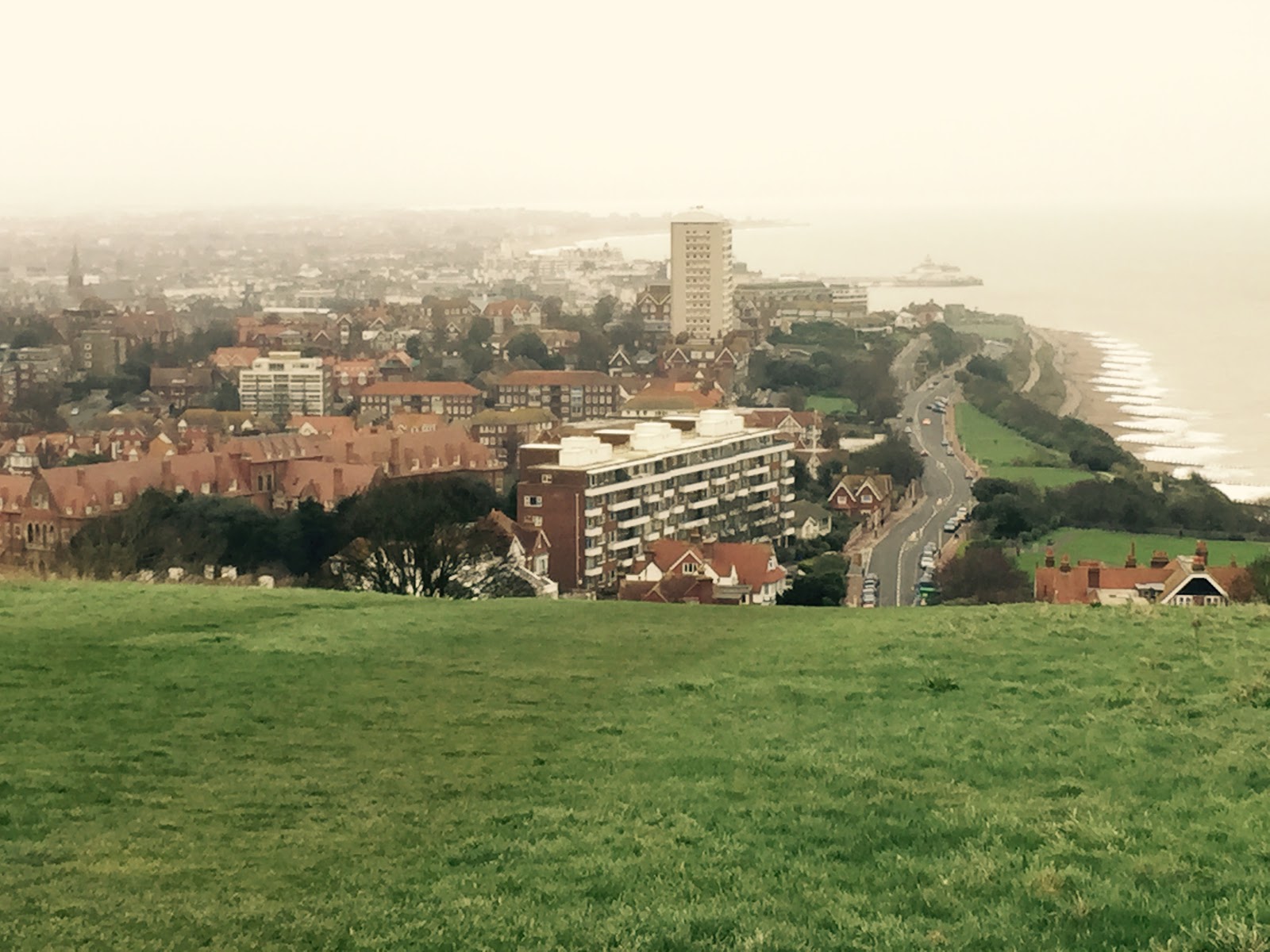
Looking down into Eastbourne

Beaches of Eastbourne


Pevensey Bay Shingle beach

Wild Ponies on Beachy Head

Pony on Beachy Head - busy grazing

The route and my timings

I took a fairly easy walk and took my time to stop to eat, admire and drink tea. My route and timings are below.


Sunday, 17 May 2015

New York - with the crowd in central park

Introduction

I can never contain my sense of excitement when thinking about going to New York City. I was fortunate enough to go there recently and the number meetings meant that it made sense for me to have a weekend there. While the day is conducive to anything more than work the evening prove invaluable in seeing the city. Now I've been to New York City before and know my way round it. But this time the trip was different. Here are some of thing I got up to.

Central Park Circuit.

I had warm evening when the office emptied at 6pm and I went back to the hotel with nothing much to do. So I put on my shorts and thought it would be worth while running around the Central Park circuit. Being the middle of spring the day was warm and the number of cherry blossom trees and the evening light were magical. But I think every man and woman on the west and east side must have had the same ideas and me as there was a bevy of different New Yorker running along side me.


Cherry Blossoms in Central Park (April)

Looking out over to the west side
A little fitness while taking pictures

Chrysler Building

Here's a photo looking up at the Chrysler building from just behind Grand Central station. Magnificent building but sadly you cannot go up to the observatory of this phenomenal building


Chrysler Building - Day time shot of the Art Deco façade

Empire State Building

The Empire state is still a building that takes your breadth away to build something so tall nearly a hundred years ago and still a functional building to this day is something. This does have an observatory but next time baby!


Grand Central Station

A beautiful ambient train station the home to many a movie and handy location for a Apple store too. No I didnt buy anything from this one.


Times Square

Times Square is always happening and you cant beat the buzz around this place. I've noticed that most places in the world have a Times Square, even out local shopping centre has a times square but nothing compares to this place.

Eye Catching H&M lady

Times Square - Circular Panorama

St. Patricks Cathedral

Here's a view of St. Patrick's cathedral sandwiched between commercial mid tow and the shops of Fifth and Madison.


Top of the Roc

This is the view from Bar65 at the top of the Rockefeller Centre. I would say this is the best way to spend your money if you're going to the top of the Roc. Yes the drink prices are extortionate but there are every where else in the world where you have a view like this.


Other places to visit

For a few evening drinks and watching the sun go down over Jersey head to down town and the Standard Hotel roof top bar.

Just across from the Standard Bar is Hog and Heifers bar - if you've seen Coyote Ugly this is the place in NYC. Sadly the place was dead on the day I went but interesting for the visitor. It looks like a biker crowd hopefully they are not territorial

Conclusion

Hopefully will be back in the Big Apple soon enough with the family in tow to properly visit the sights again and get some better pictures with proper focus and more light! Until then adieu.

Sunday, 17 November 2013

Lantau Peak Hike

You'll know there are some spectacular and challenging walks in Hong Kong. This is something you would not expect when you're presented with the bright lights of Hong Kong Island or the neon of Nathan Road, Kowloon.

This post covers the Lantau Peak hike I did. The drive behind doing was that it is the second biggest peak in Hong Kong and presented a challenge that my body was looking for on a weekend. I think anyone reasonably fit can do the walk.

Getting there

When living on Hong Kong Island the key challenge is getting there or anywhere on Lantau apart from the airport. I took the train to Tung Chung and then a bus (M3) to Pak Kung Au. The stop is not easy for the first timer to pick out but the bus ascends over a hill about half way up there is a stop and that where you get off. Follow it on some mapping software if you're unsure.

The Pak Kung Au stop spoils you for choice you can take Lantau Trail Stage 3 : Pak Kung Au over Lantau Peak to Ngong Ping or you can take Trail 2 going backwards up Sunset peak. I went on a clear day and the views would be spectacular from both.

Ascent to Lantau Peak

There is a clear sign telling you which way to go. The signs on this route are easy to follow and you're basically walking from marker 18 on the Lantau Trail up to Marker 26. You can pick out the trail see below. It was being guarded by some fairly fierce looking animals. I had to be careful.

Guardians of the Lantau Trail


Spoit for choice : Sunset peak or Lantau Peak. Lantau Peak today
The ascent starts straight away and its thankless stair climbing exercise for the next 90 minutes. The stairs are big (some knee high) so pace yourself as its like this for most of the way to the top.

Stair at the start of the ascent, its list this all the way
Thankfully alongside the constant steps that you're negotiating you will see some spectacular scenery. So stop and take your time to admire the beauty.

This is the target : Lantau Peak from the bottom


Looking back at Sunset Peak


The view down to Tung Cheung on the right
As you go higher the vistas open up even further and you can see towards Pui O and the villages below. And further out are islands floating in the South China Sea.
Vista looking back at Sunset Peak and out to the South China Sea
Some of the vegetation along the way


Its a long haul to the top, it never gets close enough


Keep going and at the top you'll be rewarded with this.


Looking down from Lantau Peak, towards Shui Hau Village


Looking down to Shek Pik Reservoir from the top.
Then once over Lantau Peak the Buddha comes into view and its an interesting climb down with some really steep steps.

Zoomed in view of the Buddha and Ngong Ping Village
The trail winds it way down and ends at the wisdom path in Ngong Ping Village. Here are some shots of the the wisdom path.


Wisdom Path Ngong Ping Village
What better way then to have some vegetarian food at the Giant Buddha restaurant. The entire walk should take about 2.5 hours. I took about 3.5 as I was taking a lot of pictures as it was a great day.


Information on the trail 

I found the link below quite useful Lantau Trail Map. There is a lot of information out there on google. Most a lot better than mine.

Monday, 14 October 2013

How not to walk the Hong Kong Trail in a day

The "Why" of walking the HK Trail

I've always been of the opinion that as a human being you should be able to wake up and say "I want to walk 50Km" or "I want to run a marathon" or whatever. Our bodies are pretty strong and so once in a while its always interesting to push yourself to see what's possible and what's not.

So with that introduction, my fad has always been walking the Hong Kong (HK) Trail in one shot. The HK Trail is a 50km trail that runs from he Peak to Big Wave Bay crossing the entire island. This blog post covers how I did it and it's a great template of to how not to do it. The story start on Sunday where feeling pretty great I packed 5 bottles of Pocari Sweat (for those not in Hong Kong, its not someone's sweat but its water with glucose and ion supplements), 3 bottles of plain water, 5 bananas, bag of walnut and almonds and the relevant maps to go with it.

How not to plan walking the trail

I thought I would be a clever boy and walk the HK trail in reverse from Big Wave Bay to the Peak. I though it would be quicker to get home. Silly me, I wouldn't do this as you're ending with an astonishing climb. Walk from marker 1 (The Peak) to marker 100 (Big Wave Bay)- it done that way for a reason!

How not to start

Catch the bus that takes you to the right destination. I caught the bus to Shek O beach allegedly via Big Wave Bay. Only the bus didn't go to Big Wave bay my starting point and I walked the 1km from Shek O Road to Big Wave Bay.

So in addition to starting the walk with a non contributory kilometre. I ended up at Big Wave Bay beach and what a wonderful day. See some of the pictures below. I asked the local shop keeper the way to the HK trail and he pointed me to the steps at the corner of the beach. Don't go there this is not where the trail starts. To my naivety I thought the step would lead to the HK trail only to realise 1300 steps later I was on the wrong trail. So now with probably 3kms wasted and the energy of a 1300 step ascent and decent back to the beach I was about to give up. But eventually I found the trail.


Climb to the top of the 1300 step at Big Wave Bay and this is what you will see - worth it if you're not about to walk 50kms

Path showing the steps - you know you are not doing the HK trail if you see this

In summary - get to the right starting point !

Section 8 - Big Wave Bay to Shek O Road

Eventually things did start to go my way and I began my walk from marker 100 counting down.


So I started walking at about 9.30am from Big Wave bay after the first our learning how not to do it. Started briskly progressing well all the way up to dragon's back following the markers as I went along


From the Dragon's Back - looking at Big Wave Bay

Front Dragon's Back - looking at Shek O 

At this stage you are doing Section 8 of the HK Trail. This is probably the best part of the trail, a thorough joy to walk this section, as the views on a clear day are unbelievable. Note, Section 8 of the HK Trail has been voted one of the best hikes in Asia. If sheer pleasure is all you are go from Cape Collinson to Shek O Road or vice-versa the rest of the section has nothing worth seeing especially if you're short of time.

Section 7 - Shek O Road to Tai Tam Reservoir

With Section 8 over in a swift couple of hours I began section 7. Descending about a 1000 steps to Stanley Bay to what is a relatively straight and easy section. This section goes from Shek O Road all the way to Tai Tam Reservoir.

The pictures below shows what you are likely to see as you venture along section 7.


Section 7 - Looking across to Stanley / Chung Hom Kok

Section 7 - Looking towards Stanley

Section 7 - A lot of the path looks like this
The paths is relatively flat in about a couple of hours you end up at Tai Tam Reservoir. So the progress so far was good as I was approaching mid-day.

Section 6 - Tai Tam to Quarry Gap

This is a nice part of HK to walk. If you have young children that Tai Tam waterworks trail is excellent. Section 6 of the HK Trail overlaps with the Tai Tam Waterworks trail. For large section the trail skirts the Tai Tam reservoir and you generally have a very nice walking environment.

The road from Tai Tam Reservoir to Quarry Gap is steep long and a relatively arduous kilometre.


Section 6 - Tai Tam Reservoir

Section 6 - Looking back at Stanley from road up to Quarry Gap
Section 5 - Quarry Gap to Wong Nai Chung Gap (The silent killer)

I lost most of my energy on this stage. After taking a break at the Quarry Gap picnic site. I started climbing the steps to Jacob's Ladder - there must be 800 to 1000 steps to the top of Mount Butler. 


Section Mount Butler - this is what you will be climbing

But you will be rewarded with some spectacular sights of the harbour. Mount Butler and Park view in my view represent the centre of HK island with view over the skyscrapers of central and the serenity of Stanley. This is something I had not appreciated despite living here in HK for a number of years.


A panorama of the view across the harbour from Mount Butler

Section 5 - Looking across the harbour to the old airport Kai Tak

Section 6 - Similar to the above but slightly different angle. You cant get enough
Form Mount Butler you go up and down relentless hills on your way to Park View. Unfortunately it takes a long time and be careful if you ever want to do this section with kids. Its a long walk and they will get tired. In my view this section drained the most energy out of me.


Section 5 - Parkview - come here
At Park view take the time to stock up on supplies - I restocked bottles of water and food. You will have no other chances. Once you're ready, follow the road down to Wong Nai Chung Gap. 


Section 5/4 - The divider
Section 4 - Wong Nai Chung to Wanchai Gap

Here I got a bit lost looking for Blacks Link but walk straight down toward Wong Nai Chung Gap and straight across the road to the bus stop and then walk toward the circle (not toward Wanchai / Causeway Bay). One of the exits to the circle is the Blacks Link. Blacks link will take you from Wong Nai Chung to Middle Road. 

A very boring and flat part of the trail unfortunately at this stage I realised that I was not going to be able to complete the whole trail during day light. So I stopped went home got my head lamp and ploughed on from middle gap.

Section 3 - Wanchai Gap to Peel Rise

Another flat and boring section of the trail - there are some nice pools of water and mini water fall of interest but a largely a trail through the woods. As night feel you would get the occasional glimpse of the Aberdeen Village through trees. At this point I was totally on my headlamp and light. Hoping the batteries would hold out on me. As without the batteries I would have to rely on my not so reliable phone. If you ever buy a headlamp make sure it Black Diamond - they are amazing and give you great range of light.

Section 2 - Peel Rise to Pokfulam Reservoir

A nice section to do at night for quite a period of this route you are looking down towards the light of Aberdeen and Pokfulam.  You're walking along the catch water similar to section 7 above. Look and admire the lights of Aberdeen and Pokfulam down below.


Section 2 - Lights of mass housing in Aberdeen

Section 2 - Looking towards Aberdeen harbour

Section 2 - Looking towards Cyberport


Section 1 - Pokfulam Reservoir to the Peak

As you approach the junction of section 1 and section 2 there is the temptation to go straight up to the Peak shaving a cool one hour of your trekking time. But be aware that is not the HK trail - its the cheating trail. So watch out for the small path veering off to the left. Although not the way you would want to walk during the middle of the night it's the real HK Trail. Taking you across Pokfulam and towards Harlech Road.

A very straight trail and you will be walking from marker 15 to marker 7 where Harlech Road starts. Harlech Road marks your final climb to the Peak circular walk. I wasnt in much of a mood to take picture of the HK from the Peak but here are a couple that I caught.


Section 1 - Looking down over central HK

Section 1 - looking across to the docks
Finishing it

Eventually as the Peak Circuit end you will come to market 1 and then zero and you will know you have done it.


So how long did it take me ?

Marker 100 at 9.35am
Marker 75 at 12.15pm
Marker 52 at 3.55pm (30 min break)
At Wanchai Gap 1 hours break (get my headlamp)
Marker 25 at 20.22
Market 0 at 23.20

It took me roughly 14 hours in duration. If you take the breaks out about 12 hours. I did it in October on a sunny day and I carried all my own water and food which is a bit of a pain. If you do this as part of the green power hike you can get support. If you plan to do this seriously get a camelbak pack so you can carry water and sip it at intervals. No point gulping down water because you are thirsty the body doesn't seem to absorb it.

Watch your nipples

A strangle comment to finish on but given you are going to be walking long period of the day your clothes will be wet. This plays havoc on area of friction like nipple (rubbing against shirts) and underwear against your thighs and lastly socks. Apparently you are meant to use vaseline to prevent this. If you don't you will wake up with sore nipples and nether regions the next day only to realise you walk all 50km of the HK Trail.


Disclaimer - I walked with a crappy Shenzhen phone hence night photo's arent up to scratch